Next Century Cities Broadband Mapping Resources
For Help With Challenges
Frequently Asked Questions
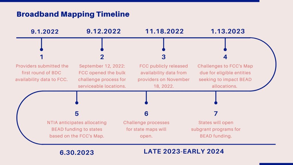
NTIA will use the FCC’s map to make BEAD funding allocations based on the number of unserved locations in each state. Unserved locations are those that don’t have access to 25/3 Mbps service. If unserved locations aren’t listed on the FCC’s map, the state will not get funding for that location. The FCC’s map will also help inform federal and state funding programs.
Federal Broadband Availability Data
Local leaders can view the Federal Communications Commission (FCC’s) current map. The FCC and many state maps focus on broadband availability, rather than broadband adoption. Oftentimes, availability is reported by providers. Some states have implemented speed tests and other measures to understand broadband performance, but the FCC’s data focus on service advertised by providers, rather than the service experienced by users. Local and state efforts play an important role in improving the FCC’s location and availability data.
Measuring Broadband Adoption
The US Census Bureau publishes statistics on computer and Internet use collected through the American Community Survey. These statistics have helped show that government efforts to connect residents during the pandemic helped improve broadband adoption.
Improving Broadband Data
Significant gaps remain, including granular price information, device breakdowns, and robust demographic information. Researchers and nonprofit advocates are pushing for more accurate federal data about broadband adoption. Accurate data helps bolster grant applications, guide policy decisions, and understand and improve broadband programs’ impact.
- Colin Rhinesmith and Rafi Santo released the report, Digital Equity Ecosystems Measurement Framework.
- Digital Planet Ex Parte | Digital Planet filed an Ex Parte filed with the FCC urging the agency to scrutinize not only the number of locations that are served but how many individuals are connected to broadband.
- Next Century Cities Mapping Letter | In July 2022, NCC submitted a letter urging the FCC to clarify the challenge process. Following the letter, NCC has continued to work with impacted community organizations, local governments, and the FCC to ensure that local voices are reflected in the map.
- Another Step Toward Better Broadband Maps (blog post by Chairwoman Rosenworcel)
Tufts University’s Digital Planet Initiative
- Summary of Digital Planet’s interactive tool, including a video on how their team recommends using its analysis to find information about your community.
- Digital Planet’s database with useful metrics is available for public use and download.
- Background on Tuft’s research and the data.
Pew Charitable Trusts
- What Is the FCC’s New Broadband Map and Why Does it Matter?
- Strategies for Crafting Effective State Broadband Plans
- Which States Have Dedicated Broadband Offices, Task Forces, Agencies, or Funds?
Institute for Local Self Reliance


